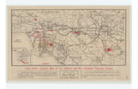
Emil Firth's correct map of Los Angeles and its tributary farming district
Item Overview
- Title
- Emil Firth's correct map of Los Angeles and its tributary farming district
- Alternative title
- Map of the four principal producing counties of Southern California; Los Angeles, Orange, San Bernardino and Riverside; comprising the justly-famed Los Angeles farming district
- Creator
-
Firth, Emil.
Violé, Félix, 1856-1925 - Date Created
- c1914
- Place of Origin
-
Los Angeles
cau - Publisher
- Emil Firth
- Language
- English
- Collection
- Henry J. Bruman Map Collection
Notes
- Description
-
Shows roads, railroads, and agricultural land; land for sale shown in red.
Copyrighted by Félix Violé.
Text on verso.
Physical Description
- Extent
- 1 map ; 32 x 66 cm, on sheet 43 x 71 cm, folded to 12 x 19 cm.
Keywords
- Genre
- map
- Location
- California, Southern
- Resource type
- cartographic
- Subjects
-
Real property--California, Southern--Maps
Agricultural resources--California, Southern--Maps
Land capability for agriculture--California, Southern--Maps
Find This Item
- Repository
- University of California, Los Angeles. Library. Henry J. Bruman Map Collection
- ARK
- ark:/21198/zz002c19q9
- Opac url
- https://search.library.ucla.edu/permalink/01UCS_LAL/17p22dp/alma9966493783606533
- Manifest url
-

Access Condition
- Rights statement
- public domain