Carta de rancherías á fechas San Gabrielinas
Item Overview
- Title
- Carta de rancherías á fechas San Gabrielinas
- Date Created
- [183-?]
- Place of Origin
- cau
- Collection
- Henry J. Bruman Map Collection
Notes
- Description
-
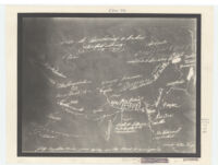
Shows ranchos, missions, etc.
Pictorial map covering area between the Mission Santa Barbara and to the south and east of Mission San Gabriel.
Photocopy of ms. map in the Archives of the Santa Barbara Mission.
Physical Description
- Extent
- 1 map : photocopy ; 19 x 24 cm.
Keywords
- Genre
-
map
spa - Subject Geographic
- California, Southern--Maps
- Location
- California, Southern
- Resource type
- cartographic
- Subjects
- Land grants--California, Southern--Maps
Find This Item
- Repository
- University of California, Los Angeles. Library. Henry J. Bruman Map Collection
- ARK
- ark:/21198/zz002c1993
- Opac url
- https://search.library.ucla.edu/permalink/01UCS_LAL/17p22dp/alma9966325923606533
- Manifest url
-

Access Condition
- Rights statement
- public domain