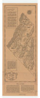
General map of Inyo County, California
Item Overview
- Title
- General map of Inyo County, California
- Creator
-
Inyo-Mono Association.
Roth, Paul. - Date Created
- [ca. 1939]
- Place of Origin
-
Bishop, Calif
cau - Publisher
- Inyo-Mono Association
- Language
- English
- Collection
- Henry J. Bruman Map Collection
Notes
- Description
-
Relief represented by hachures.
Paul Roth.
"Printed by Chalfant Press."
North oriented toward upper right.
Shows roads, mileage, lakes, camps, and accomodations.
"Especially prepared for Inyo-Mono Association"--Verso, in legend.
Physical Description
- Extent
- 2 maps on 1 sheet : both sides ; 46 x 19 cm. or smaller, sheet 56 x 22 cm.
Keywords
- Genre
- map
- Subject Geographic
-
Mono County (Calif.)--Maps
Inyo County (Calif.)--Maps - Location
-
Inyo County (Calif.)
California
Mono County (Calif.) - Resource type
- cartographic
- Subjects
-
Outdoor recreation--California--Inyo County--Maps
Outdoor recreation--California--Mono County--Maps
Find This Item
- Repository
- University of California, Los Angeles. Library. Henry J. Bruman Map Collection
- ARK
- ark:/21198/zz002c17xf
- Opac url
- https://search.library.ucla.edu/permalink/01UCS_LAL/17p22dp/alma9966174703606533
- Manifest url
-

Access Condition
- Rights statement
- copyrighted