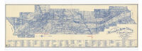
Geological map of the Mother Lode Belt in the El Dorado & Amador counties, California
Item Overview
- Title
- Geological map of the Mother Lode Belt in the El Dorado & Amador counties, California
- Uniform title
- Mother Lode Belt in the El Dorado & Amador counties, California
- Creator
- Lahiff, Henry.
- Date Created
-
1897
1897, rpr. 1939 - Place of Origin
-
Placerville
cau - Publisher
- Henry Lahiff
- Language
- English
- Collection
- Henry J. Bruman Map Collection
Notes
- Description
-
Blueline photocopy.
Also shows mining claims.
Includes list of mines by township and range.
compiled by Henry Lahiff, civil engineer, U.S. Deputy mineral surveyor, Placerville, Cal.
Physical Description
- Extent
- 1 map : photo reprod. ; 42 x 134 cm.
Keywords
- Genre
- map
- Location
-
El Dorado County
Mother Lode (Calif.)
Mother Lode
Amador County
California - Resource type
- cartographic
- Subjects
-
Geology--California--Mother Lode--Maps
Gold mines and mining--California--Mother Lode--Maps
Mining claims--California--Amador County--Maps
Mother Lode (Calif.)--Maps
Mining claims--California--El Dorado County--Maps
Find This Item
- Repository
- University of California, Los Angeles. Library. Henry J. Bruman Map Collection
- ARK
- ark:/21198/zz002c17pt
- Opac url
- https://search.library.ucla.edu/permalink/01UCS_LAL/17p22dp/alma9920463633606533
- Manifest url
-

Access Condition
- Rights statement
- public domain