Explorers map of the Pacific Crest Trailway through Southern California
Item Overview
- Title
- Explorers map of the Pacific Crest Trailway through Southern California
- Date Created
- [ca. 1939]
- Place of Origin
-
xx
[S.l] - Publisher
- s.n.
- Language
- English
- Collection
- Henry J. Bruman Map Collection
Notes
- Description
-
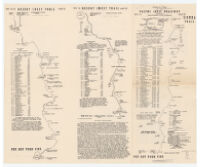
Includes trail mileages, altitudes, terrain and conditions; names of Trailway peaks, lakes and passes; food list; nomenclature; and text.
Shows route maps of the Pacific Crest Trailway from Siberian Pass near Sequoia National Park to the Mexican border.
Relief represented by spot heights.
Physical Description
- Extent
- 6 maps on 1 sheet, both sides ; sheet 32 x 38 cm., folded to 16 x 13 cm.
Keywords
- Genre
- map
- Location
-
Pacific Crest Trail
California, Southern - Resource type
- cartographic
- Subjects
-
Trails--California, Southern--Maps
Pacific Crest Trail--Maps
Find This Item
- Repository
- University of California, Los Angeles. Library. Henry J. Bruman Map Collection
- ARK
- ark:/21198/zz002c16wf
- Opac url
- https://search.library.ucla.edu/permalink/01UCS_LAL/17p22dp/alma9966158563606533
- Manifest url
-

Access Condition
- Rights statement
- copyrighted