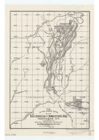
The ancient channel system between San Andreas and Mokelumne Hill, Calavaras Co
Item Overview
- Title
- The ancient channel system between San Andreas and Mokelumne Hill, Calavaras Co
- Uniform title
- Channel system between San Andreas and Mokelumne Hill, Calaveras Co
- Creator
- Storms, William H. b. 1859.
- Date Created
- 1894
- Place of Origin
-
[Sacramento, Calif.]
cau - Publisher
- California State Mining Bureau
- Language
- English
- Collection
- Henry J. Bruman Map Collection
Notes
- Description
-
Blackline print.
Relief represented by hachures.
"Reprinted from Report XII of State Mineralogist, p. 486."
Shows also mines and townships.
State Mining Bureau, J.J. Crawford, State Mineralogist ; by W.H. Storms, assistant in field.
Physical Description
- Extent
- 1 map : photocopy ; 37 x 25 cm.
Keywords
- Genre
- map
- Names
-
California State Mining Bureau.
Crawford, J. J. - Subject Geographic
- California--Maps
- Location
-
California
Calaveras County - Resource type
- cartographic
- Subjects
-
Mines and mineral resources--California--Calaveras County--Maps
Gold mines and mining--California--Calaveras County--Maps
Find This Item
- Repository
- University of California, Los Angeles. Library. Henry J. Bruman Map Collection
- ARK
- ark:/21198/zz002c16qv
- Opac url
- https://search.library.ucla.edu/permalink/01UCS_LAL/17p22dp/alma9932526603606533
- Manifest url
-

Access Condition
- Rights statement
- pd_usfed