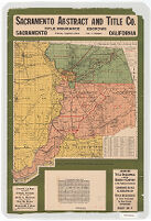
Map of Sacramento County, Cal., and adjacent areas
Item Overview
- Title
- Map of Sacramento County, Cal., and adjacent areas
- Creator
- Kenyon Company (Des Moines, Iowa).
- Date Created
-
1931
[1931?] - Place of Origin
-
iau
Des Moines, Iowa - Publisher
- Kenyon Co.
- Language
- English
- Collection
- Henry J. Bruman Map Collection
Notes
- Description
-
Text above map: "Sacramento Abstract and Title Co."
Shows locations "where newspapers of general circulation are published."
Includes calendar for 1931.
Shows cities and towns, counties, townships, roads, railroads, "colonies and sub divisions" in Sacramento County and portions of Yolo, Solano and San Joaquin Counties.
Indexed.
Physical Description
- Extent
- 1 map : col. ; 56 x 48 cm. on sheet 82 x 55 cm.
Keywords
- Genre
- map
- Subject Geographic
-
Solano County (Calif.)--Maps
Sacramento County (Calif.)--Administrative and political divisions--Maps
Sacramento County (Calif.)--Maps
San Joaquin County (Calif.)--Maps - Location
-
San Joaquin County (Calif.)
Solano County (Calif.)
Yolo County (Calif.)
Sacramento County (Calif.) - Resource type
- cartographic
Find This Item
- Repository
- University of California, Los Angeles. Library. Henry J. Bruman Map Collection
- ARK
- ark:/21198/zz002c16j8
- Opac url
- https://search.library.ucla.edu/permalink/01UCS_LAL/17p22dp/alma9966101833606533
- Manifest url
-

Access Condition
- Rights statement
- copyrighted