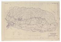
Water service areas, San Joaquin Basin
Item Overview
- Title
- Water service areas, San Joaquin Basin
- Uniform title
- Sacramento San Joaquin basins, California
- Creator
- United States. Army. Corps of Engineers.
- Date Created
- 1943
- Place of Origin
-
Sacramento, Calif
cau - Publisher
- U.S. Engineer Office
- Language
- English
- Collection
- Henry J. Bruman Map Collection
Notes
- Description
-
"SJ-13-1."
"This map adopted from Plate VI State bulletin no. 29, San Joaquin River Basin, 1931, from maps by the U.S. Bureau of Reclamation and from other sources."
Oriented with north toward upper left.
Includes chart of "Sources of water supply."
Physical Description
- Extent
- 1 map : photocopy ; 65 x 98 cm.
Keywords
- Genre
- map
- Subject Geographic
- San Joaquin Valley (Calif.)--Maps
- Location
-
westernmost:W1223000
California
easternmost:W1180000
San Joaquin Valley (Calif.)
southernmost:N0350000
northernmost:N0390000 - Resource type
- cartographic
- Subjects
- Water-supply--California--San Joaquin Valley--Maps
Find This Item
- Repository
- University of California, Los Angeles. Library. Henry J. Bruman Map Collection
- ARK
- ark:/21198/zz002c16g7
- Opac url
- https://search.library.ucla.edu/permalink/01UCS_LAL/17p22dp/alma9966101883606533
- Manifest url
-

Access Condition
- Rights statement
- pd_usfed