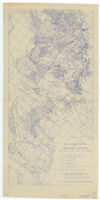
Soil classification and irrigation districts
Item Overview
- Title
- Soil classification and irrigation districts
- Creator
- United States. Bureau of Agricultural Economics.
- Date Created
-
1943
[1943?] - Place of Origin
-
[Berkeley, Calif]
cau - Publisher
- Bureau of Agricultural Economics
- Language
- English
- Collection
- Henry J. Bruman Map Collection
Notes
- Description
-
Incomplete; soil grades and Storie index rating not shown; appears to be the southern half of a two-sheet map.
"Prepared by the Bureau of Agricultural Economics, Berkeley, California, for the Central Valley Project Studies."
Oriented with the north toward the upper right.
Sources: "Soil classification" map by Walter W. Weir and R. Earl Storie, Division of Soil Technology, University of California, 1936; "Active and organized irrigation districts" map by the Bureau of Reclamation, Sacramento, California, 1943.
Blue line print.
Shows irrigation districts.
Area covered extends from Fresno to Bakersfield.
Physical Description
- Extent
- 1 map : photocopy ; 84 x 40 cm.
Keywords
- Genre
- map
- Location
-
San Joaquin Valley
California
San Joachin Valley (Calif.) - Resource type
- cartographic
- Subjects
-
Irrigation districts--California--San Joaquin Valley--Maps
San Joachin Valley (Calif.)--Maps
Find This Item
- Repository
- University of California, Los Angeles. Library. Henry J. Bruman Map Collection
- ARK
- ark:/21198/zz002c1663
- Opac url
- https://search.library.ucla.edu/permalink/01UCS_LAL/17p22dp/alma9966173423606533
- Manifest url
-

Access Condition
- Rights statement
- pd_usfed