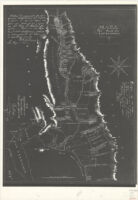
Mapa del Valle del Sacramento
Item Overview
- Title
- Mapa del Valle del Sacramento
- Creator
- Bidwell, John. 1819-1900.
- Date Created
- [1851?]
- Place of Origin
- cau
- Language
- English
- Collection
- Henry J. Bruman Map Collection
Notes
- Description
-
Includes text.
Negative photocopy on 2 sheets of ms. map.
Relief represented by hachures.
"Certifico ... March 26 de 1851 ..."
"No. 147 Charles Covillaud, et al. Rancho de Honcut, filed office Sept. 6, 1853, Geo. Fisher."
Shows drainage, ranchos, land ownership, etc.
John Bidwell].
Physical Description
- Extent
- 1 map : photocopy ; 59 x 44 cm.
Keywords
- Genre
-
map
spa - Names
- Wheat, Carl I. (Carl Irving). 1892-1966.
- Subject Geographic
- Sacramento Valley (Calif.)--Maps
- Location
-
Sacramento Valley (Calif.)
southernmost:N0373000
California
northernmost:N0400000
westernmost:W1221000
easternmost:W1211500 - Resource type
- cartographic
- Subjects
-
Real property--California--Sacramento Valley--Maps
Land grants--California--Sacramento Valley--Maps
Find This Item
- Repository
- University of California, Los Angeles. Library. Henry J. Bruman Map Collection
- ARK
- ark:/21198/zz002c15xg
- Opac url
- https://search.library.ucla.edu/permalink/01UCS_LAL/17p22dp/alma9966046443606533
- Manifest url
-

Access Condition
- Rights statement
- public domain