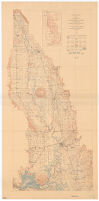
Topographic map of the Sacramento Valley, California
Item Overview
- Title
- Topographic map of the Sacramento Valley, California
- Creator
- Geological Survey (U.S.).
- Date Created
- 1911
- Place of Origin
-
[Washington, D.C.]
dcu - Publisher
- U.S. Geological Survey
- Language
- English
- Collection
- Henry J. Bruman Map Collection
Notes
- Description
-
Relief represented by contours.
Contour interval 25 feet.
Includes "index to topographic maps of Sacramento Valley" and "conventional signs."
Reduced from U.S. Geological Survey Atlas sheets, surveyed in 1903-1910 in cooperation with the State of California; R.B. Marshall, Chief Geographer. - Caption
- Ed. of Oct. 1911.
Physical Description
- Extent
- 1 map : col. ; 100 x 47 cm.
Keywords
- Genre
-
map
Topographic maps. - Location
-
northernmost:N0401500
southernmost:N0380000
Sacramento Valley (Calif.)
westernmost:W1221500
easternmost:W1210000 - Resource type
- cartographic
- Subjects
- Sacramento Valley (Calif.)--Maps
Find This Item
- Repository
- University of California, Los Angeles. Library. Henry J. Bruman Map Collection
- ARK
- ark:/21198/zz002c15qc
- Opac url
- https://search.library.ucla.edu/permalink/01UCS_LAL/17p22dp/alma9915070473606533
- Manifest url
-

Access Condition
- Rights statement
- pd_usfed