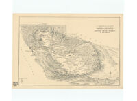
Panoramic perspective of Central Valley Project of California
Item Overview
- Title
- Panoramic perspective of Central Valley Project of California
- Creator
- United States. Bureau of Reclamation.
- Date Created
-
[1938?]
1938 - Place of Origin
-
[Washington, D.C.]
dcu - Publisher
- U.S. Dept. of the Interior, Bureau of Reclamation
- Language
- English
- Collection
- Henry J. Bruman Map Collection
Notes
- Description
-
A.A. Abel.
Covers California from the Oregon border to the Mohave Desert.
Relief represented by spot heights.
Shows canals, power transmission lines, pumping plants, dams, etc.
Physical Description
- Extent
- 1 map ; 24 x 36 cm.
Keywords
- Genre
- map
- Names
- Abel, A. A.
- Subject Geographic
- Central Valley (Calif. : Valley)--Maps
- Location
-
Central Valley (Calif. : Valley)
California
Central Valley (Valley) - Resource type
- cartographic
- Subjects
-
Water resources development--California--Central Valley (Valley)--Maps
Dams--California--Central Valley (Valley)--Maps
Pumping stations--California--Central Valley (Valley)--Maps
Electric lines--California--Central Valley (Valley)--Maps
Canals--California--Central Valley (Valley)--Maps
Find This Item
- Repository
- University of California, Los Angeles. Library. Henry J. Bruman Map Collection
- ARK
- ark:/21198/zz002c15nb
- Opac url
- https://search.library.ucla.edu/permalink/01UCS_LAL/17p22dp/alma9966187953606533
- Manifest url
-

Access Condition
- Rights statement
- pd_usfed