Metropolitan Water District Aqueduct general location map
Item Overview
- Title
- Metropolitan Water District Aqueduct general location map
- Creator
- Metropolitan Water District of Southern California (Calif.).
- Date Created
-
193u
[193-?] - Place of Origin
-
[Los Angeles?]
cau - Publisher
- Metropolitan Water District
- Language
- English
- Collection
- Henry J. Bruman Map Collection
Notes
- Description
-
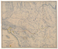
"F.E. Weymouth, Chief Engineer."
Shows the route of the Colorado River Aqueduct from Cajalco Reservoir on the west, to the Colorado River at Parker Intake, including grades and construction types, such as tunnel and lined canal.
Blueline print.
Includes portions of western Nevada and western Arizona.
Printed on cloth.
Aqueduct grade and construction type are hand-colored.
Relief represented by contours.
Physical Description
- Extent
- 1 map : photocopy, hand col. ; 121 x 143 cm.
Keywords
- Genre
- map
- Location
-
easternmost:W1132500
westernmost:W1190000
southernmost:0323000
Colorado River Aqueduct (Calif.)
northernmost:N0362000
California, Southern - Resource type
- cartographic
- Subjects
-
Aqueducts--California, Southern--Maps
Water-supply--California, Southern--Maps
Colorado River Aqueduct (Calif.)--Maps
Find This Item
- Repository
- University of California, Los Angeles. Library. Henry J. Bruman Map Collection
- ARK
- ark:/21198/zz002c1595
- Opac url
- https://search.library.ucla.edu/permalink/01UCS_LAL/17p22dp/alma9966031773606533
- Manifest url
-

Access Condition
- Rights statement
- unknown