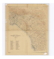
Map of a part of Southern California, showing gaging stations
Item Overview
- Title
- Map of a part of Southern California, showing gaging stations
- Creator
- Geological Survey (U.S.).
- Date Created
- 1920
- Place of Origin
-
[Washington, D.C.]
cau - Publisher
- U.S. Geological Survey
- Language
- English
- Collection
- Henry J. Bruman Map Collection
Notes
- Description
-
Map is plate 1 and 2 from the U.S. Geological Survey's Water- supply paper 447.
Relief represented by contours.
Includes index.
Physical Description
- Extent
- 1 map on 2 sheets : col. ; sheets 59 x 89 cm. and 102 x 86 cm.
Find This Item
- Repository
- University of California, Los Angeles. Library. Henry J. Bruman Map Collection
- ARK
- ark:/21198/zz002c14zh
- Opac url
- https://search.library.ucla.edu/permalink/01UCS_LAL/17p22dp/alma9915055693606533
- Manifest url
-

Access Condition
- Rights statement
- pd_usfed