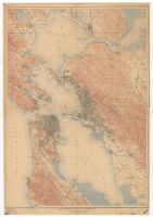
San Francisco and vicinity, California, 1915
Item Overview
- Title
- San Francisco and vicinity, California, 1915
- Uniform title
- California, San Francisco and vicinity
- Creator
- Geological Survey (U.S.).
- Date Created
- 1915
- Place of Origin
-
[Washington, D.C.]
dcu - Publisher
- The Survey
- Language
- English
- Collection
- Henry J. Bruman Map Collection
Notes
- Description
-
from Geological Survey atlas sheets surveyed in 1892-1913.
Relief represented by contours.
"Culture revision of San Francisco, Oakland, Alameda, Berkeley and Richmond in 1913-1914. R.B. Marshall, chief geographer."
Contour interval 25 feet. Datum is mean sea level.
Covers San Francisco and San Pablo Bay areas.
Physical Description
- Extent
- 1 map : col. ; 118 x 84 cm.
Keywords
- Genre
-
map
Topographic maps. - Names
- Marshall, R. B.
- Subject Geographic
- San Francisco Bay Area (Calif.)--Maps
- Location
-
westernmost:W1223500
southernmost:N0373000
northernmost:N0381000
easternmost:W1220100
San Francisco Bay Area (Calif.) - Resource type
- cartographic
Find This Item
- Repository
- University of California, Los Angeles. Library. Henry J. Bruman Map Collection
- ARK
- ark:/21198/zz002c14g8
- Opac url
- https://search.library.ucla.edu/permalink/01UCS_LAL/17p22dp/alma9915067493606533
- Manifest url
-

Access Condition
- Rights statement
- pd_usfed