California Tobias Peak quadrangle
Item Overview
- Title
- California Tobias Peak quadrangle
- Uniform title
-
Tobias Peak, Calif., East half
Tobias Peak quadrangle - Date Created
- [1936?]
- Place of Origin
-
Washington, D.C
dcu - Publisher
- U.S. Dept. of the Interior, Geological Survey
- Language
- English
- Collection
- Henry J. Bruman Map Collection
Notes
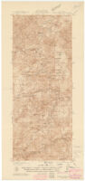
- Description
-
Includes location map, "Diagram of township," and notes.
Relief represented by contours.
topography by Lee Morrison and S.N. Stoner.
Surveyed in 1932 and 1936.
Contour interval 100 feet.
"State of California."
Physical Description
- Extent
- 1 map : col. ; 58 x 24 cm.
Keywords
- Genre
- map
- Names
-
Morrison, Lee.
Stoner, S. N.
Geological Survey (U.S.). - Subject Geographic
-
California--Maps
Kern County (Calif.)--Maps
Tulare County (Calif.)--Maps - Location
-
Kern County (Calif.)
southernmost:N0353000
easternmost:W1183000
northernmost:N0360000
California
Tulare County (Calif.)
westernmost:W1184500 - Resource type
- cartographic
Find This Item
- Repository
- University of California, Los Angeles. Library. Henry J. Bruman Map Collection
- ARK
- ark:/21198/zz002c12x1
- Opac url
- https://search.library.ucla.edu/permalink/01UCS_LAL/17p22dp/alma9965978553606533
- Manifest url
-

Access Condition
- Rights statement
- pd_usfed