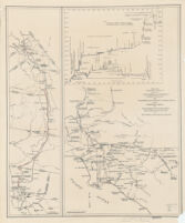
Map and condensed profile showing Los Angeles Aqueduct, completed in 1913, and proposed extension to Mono Basin
Item Overview
- Title
- Map and condensed profile showing Los Angeles Aqueduct, completed in 1913, and proposed extension to Mono Basin
- Creator
- Los Angeles (Calif.). Bureau of Water Works & Supply.
- Date Created
-
1930
[1933?] - Place of Origin
-
[Los Angeles, Calif.?]
cau - Publisher
- Bureau of Water Works and Supply?
- Language
- English
- Collection
- Henry J. Bruman Map Collection
Notes
- Description
-
One map shows southern portion of Los Angeles Aqueduct (to Fairmont Reservoir) and the route of the Colorado River Aqueduct; the other map shows the Los Angeles Aqueduct and proposed Mono Craters Tunnel.
Photostat.
Los Angeles Aqueduct hand colored in red and blue on one map.
Physical Description
- Extent
- 2 maps on 1 sheet : photocopy ; 51 x29 cm. and 51 x 13 cm., sheet 55 x 46 cm.
Keywords
- Genre
- map
- Location
-
Los Angeles Aqueduct (Calif.)
California - Resource type
- cartographic
- Subjects
-
Water-supply--California--Los Angeles--Maps
Los Angeles Aqueduct (Calif.)--Maps
Aqueducts--California--Maps
Find This Item
- Repository
- University of California, Los Angeles. Library. Henry J. Bruman Map Collection
- ARK
- ark:/21198/zz002c12mc
- Opac url
- https://search.library.ucla.edu/permalink/01UCS_LAL/17p22dp/alma9966025693606533
- Manifest url
-

Access Condition
- Rights statement
- pd_usfed