A general map of California during Spanish and Mexican occupation
Item Overview
- Title
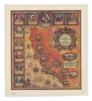
- A general map of California during Spanish and Mexican occupation
- Creator
- Lauritzen, Dillon.
- Date Created
-
c1929
1929 - Place of Origin
-
cau
[California? - Publisher
- s.n.]
- Language
- English
- Collection
- Henry J. Bruman Map Collection
Notes
- Description
-
Includes ports. and ill.
map drawn by Dillon Lauritzen.
Relief represented pictorially.
Physical Description
- Extent
- 1 map : col. ; 56 x 47 cm.
Keywords
- Genre
- map
- Location
-
southernmost:NO323200
easternmost:W1140700
California
westernmost:W1242500
northernmost:NO420000 - Resource type
- cartographic
- Subjects
- California--History--To 1846--Maps
Find This Item
- Repository
- University of California, Los Angeles. Library. Henry J. Bruman Map Collection
- ARK
- ark:/21198/zz002bfss2
- Opac url
- https://search.library.ucla.edu/permalink/01UCS_LAL/17p22dp/alma9920564103606533
- Manifest url
-

Access Condition
- Rights statement
- copyrighted