Population 1935
Item Overview
- Title
- Population 1935
- Creator
- United States. Bureau of Agricultural Economics.
- Date Created
-
1935
[1935] - Place of Origin
-
xx
[S.l.] - Publisher
- The Division
- Language
- English
- Collection
- Henry J. Bruman Map Collection
Notes
- Description
-
U.S. Dept. of Agriculture, Bureau of Agricultural Economics, Div. of Land Economics ; with the valuable assistance of the U.S. Forest Service.
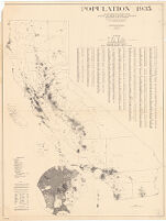
Includes 2 insets, county outline map, index with population figures, and notes.
Shows population by the dot method.
"Population research and analysis and preparation--conducted under the direction of Philip J. Webster, State Land Use Planning Specialist for California, Bureau of Agricultural Economics--by George A. Gendron; assisted by Edmond O. Burger; Cartography by Walter R. Pilcher."
Physical Description
- Extent
- 1 map ; 123 x 93 cm.
Keywords
- Genre
- map
- Names
- United States. Forest Service.
- Location
-
easternmost:W1140700
northernmost:N0420000
southernmost:N0323700
California
westernmost:W1242200 - Resource type
- cartographic
- Subjects
- California--Population--Maps
Find This Item
- Repository
- University of California, Los Angeles. Library. Henry J. Bruman Map Collection
- ARK
- ark:/21198/zz002bc4rg
- Opac url
- https://search.library.ucla.edu/permalink/01UCS_LAL/17p22dp/alma9934692093606533
- Manifest url
-

Access Condition
- Rights statement
- pd_usfed