Geomorphic map of California
Item Overview
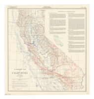
- Title
- Geomorphic map of California
- Creator
- Jenkins, Olaf Pitt. 1889-.
- Date Created
- 1938, reprinted 1969
- Place of Origin
-
San Francisco
cau - Publisher
- California Division of Mines and Geology
- Language
- English
- Collection
- Henry J. Bruman Map Collection
Notes
- Description
-
"Surface contour interval 2000 feet;" "Submarine contour interval 250 fathoms."
Alternate title: Geomorphic map 1969.
Includes text and outline map of "Geomorphic provinces."
prepared by Olaf P. Jenkins 1938.
Shows geomorphic provinces and selected faults.
Originally issued as an inset on the Geologic map of California, Olaf P. Jenkins edition of 1938.
Physical Description
- Extent
- 1 map : col. ; 53 x 50 cm.
Keywords
- Genre
- map
- Location
-
easternmost:W1140700
northernmost:N0420000
southernmost:N0323700
California
westernmost:W1242200 - Resource type
- cartographic
- Subjects
-
Faults (Geology)--California--Maps
Geomorphology--California--Maps
Find This Item
- Repository
- University of California, Los Angeles. Library. Henry J. Bruman Map Collection
- ARK
- ark:/21198/zz002bc4jc
- Opac url
- https://search.library.ucla.edu/permalink/01UCS_LAL/17p22dp/alma9918265813606533
- Manifest url
-

Access Condition
- Rights statement
- pd_usfed