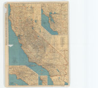
Rand McNally standard map of California.
Item Overview
- Title
- Rand McNally standard map of California.
- Alternative title
- Rand McNally senior 1935 auto road map of California, Nevada
- Creator
- Rand McNally and Company.
- Date Created
- [1935]
- Place of Origin
-
ilu
Chicago - Publisher
- Rand McNally
- Language
- English
- Collection
- Henry J. Bruman Map Collection
Notes
- Description
-
Insets: San Francisco and vicinity -- Los Angeles and vicinity -- San Diego and vicinity.
Relief represented by hachures.
Accompanied by text: Rand McNally pocket maps of California for tourists, travelers, shippers, general commercial and business reference.
Edition statement from text.
Index of railroads.
On verso: Rand McNally senior 1935 auto road map of California, Nevada.
Rand McNally and Company.
Shows railroads, electric lines, and navigable canals. - Note
- 1935 ed.
Physical Description
- Extent
- 1 map : col. ; 89 x 65 cm. + text (64 p. ; 24 cm.)
Keywords
- Genre
- map
- Location
- California
- Resource type
- cartographic
- Subjects
-
Railroads--California--Maps
Roads--California--Maps
Find This Item
- Repository
- University of California, Los Angeles. Library. Henry J. Bruman Map Collection
- ARK
- ark:/21198/zz002b9427
- Opac url
- https://search.library.ucla.edu/permalink/01UCS_LAL/17p22dp/alma9927971053606533
- Manifest url
-

Access Condition
- Rights statement
- copyrighted