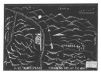
[Map of "Mission of San Miguel," San Luis Obispo County, California].
Item Overview
- Title
- [Map of "Mission of San Miguel," San Luis Obispo County, California].
- Date Created
- 19--]
- Place of Origin
-
[S.l
cau - Publisher
- s.n.
- Collection
- Henry J. Bruman Map Collection
Notes
- Description
-
From: U.S. District Court. California, Southern District. Land case 326 SD, page 58; land case map D-1366 (Bancroft Library).
Map in Spanish, label at lower right corner in English.
Negative photographic reproduction of ms. col. map: [184-?].
Label affixed to original map: No. 326 S.D. Petronillo Rios, clmt., "Mission of San Miguel," San Luis Obispo County, 1366.
Relief represented pictorially.
Physical Description
- Extent
- 1 map : photocopy, negative ; 30 x 43 cm.
Keywords
- Genre
-
map
spa - Names
- Rios, Petronillo.
- Location
-
northernmost:N0354440
southernmost:N0354440
westernmost:W1204149
California
easternmost:W1204149
San Luis Obispo County - Resource type
- cartographic
- Subjects
- Missions--California--San Luis Obispo County--History--Maps
Find This Item
- Repository
- University of California, Los Angeles. Library. Henry J. Bruman Map Collection
- ARK
- ark:/21198/zz002b1pc1
- Opac url
- https://search.library.ucla.edu/permalink/01UCS_LAL/17p22dp/alma9966665143606533
- Manifest url
-

Access Condition
- Rights statement
- unknown