Photo spot index aerial photographic project CDF 2 (1948)
Item Overview
- Title
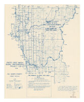
- Photo spot index aerial photographic project CDF 2 (1948)
- Uniform title
- Del Norte County, Humboldt Meridian,1942
- Creator
- United States. Forest Service.
- Date Created
-
1949
[1949] - Place of Origin
-
San Francisco
cau - Publisher
- U.S. Forest Service
- Language
- English
- Collection
- Henry J. Bruman Map Collection
Notes
- Description
-
Relief represented by hachures.
Index map of a photographic survey conducted by U.S. Forest Service.
Blue line print.
"1927 North American datum."
"Original sheets prepared by the Department of Public Works, Division of Highways in cooperation with the U.S. Department of Agriculture, Bureau of Public Roads. Original data obtained from State-wide Highway Planning Survey, 1937. Original sheets assembled with alterations and additions required by the Department of Natural Resources, Division of Forestry, 1941."
Includes townships and sections.
Physical Description
- Extent
- 1 map : photocopy ; 66 x 53 cm.
Keywords
- Genre
- map
- Location
- Del Norte County (Calif.)
- Resource type
- cartographic
- Subjects
- Del Norte County (Calif.)--Maps
Find This Item
- Repository
- University of California, Los Angeles. Library. Henry J. Bruman Map Collection
- ARK
- ark:/21198/zz00297jt3
- Opac url
- https://search.library.ucla.edu/permalink/01UCS_LAL/17p22dp/alma9966493813606533
- Manifest url
-

Access Condition
- Rights statement
- pd_usfed