Map of Los Angeles
Item Overview
- Title
- Map of Los Angeles
- Date Created
- circa 1913
- Date
- 1908/1918
- Place of Origin
- Los Angeles, Calif.
- Publisher
- Los Angeles Investment Company
- Language
- English
- Collection
- Tract Maps and Cadastral Maps of Southern California, 1868-1937
Notes
- Description
-
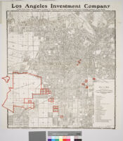
Caption above map: "Los Angeles Investment Company, largest real estate and investment company in Western America and largest co-operative building company in the world"
"Correct to Aug. 15, 1913"
Scale not given
Key to map of LA Investment Company properties. Numbered parcels are outlined in red. Verso has an index to Los Angeles streets.
Digitization took place as part of the California Cultures Project.
Physical Description
- Extent
- 1 map: some col.
- Dimensions
- 70 x 68 cm. on sheet 76 x 71 cm. originally folded to 12.5 x 7.5 cm. and tipped into cover 13.5 x 8.5 cm.
Keywords
- Genre
-
cartographic
cadastral maps - Location
- Los Angeles (Calif.)--Maps
- Resource type
- still image
- Subjects
- Real property--California--Los Angeles--Maps
Find This Item
- Repository
- University of California, Los Angeles. Library Special Collections
- Local Identifier
-
clusc_1_1_00017053a
uclamss_349_b5_2-front
clusc_1_1_00017054a
uclamss_349_b5_2-back - ARK
- ark:/21198/zz001d2sgx
- Manifest url
-

Access Condition
- Rights statement
- public domain