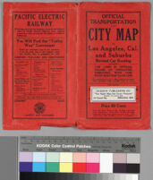
Official transportation and city map of Los Angeles, California and suburbs
Item Overview
- Title
- Official transportation and city map of Los Angeles, California and suburbs
- Date Created
- 1911
- Date
- 1911
- Place of Origin
- Los Angeles, Calif.
- Publisher
- Times-Mirror Printing & Binding House
- Language
- English
- Collection
- Pamphlet Maps Collection 1750-1965
Notes
- Description
-
Scale not given
Digitization took place as part of the California Cultures Project.
"Pacific Electric Raiway Company, routes of interurban system operating to points indicated at margin of map. Color of cars and lines on map [red]"
"Glendale & Eagle Rock Ry [blue]"
Relief shown by spot heights. "Copyright 1911 by Laura L. Whitlock for Los Angeles Ry."
Physical Description
- Extent
- 1 map : col.
- Dimensions
- 111.5 x 75 cm. on sheet 114.5 x 80.5 cm.
Keywords
- Genre
-
maps
pamphlets - Names
-
Pacific Electric Railway Company--Maps
Los Angeles Railway--Maps - Resource type
-
still image
cartographic - Subjects
-
Transportation--California--Los Angeles Metropolitan Area
Street-railroads--California--Los Angeles Metropolitan Area--Maps
Street railroads--California--Glendale Metropolitan Area
Find This Item
- Repository
- University of California, Los Angeles. Library Special Collections
- Local Identifier
-
clusc_1_1_00017505a
uclamss_990_b31_3-front
uclamss_990_b31_3-map
clusc_1_1_00017504a - ARK
- ark:/21198/zz001d1ftt
- Manifest url
-

Access Condition
- Rights statement
- public domain