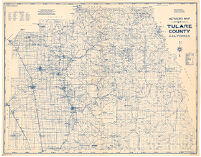
Metsker's map of Tulare County, California
Item Overview
- Title
- Metsker's map of Tulare County, California
- Creator
- Chas. F. Metsker
- Date Created
- 1940
- Date
- 1940
- Place of Origin
- Tacoma, Wash.
- Publisher
- Metsker Maps
- Language
- English
- Collection
- Henry J. Bruman Map Collection
Notes
- Description
-
"2-40."
Includes list of judicial townships.
Blue line print.
Relief shown by hachures and spot heights.
Physical Description
- Extent
- 1 map : photocopy
- Dimensions
- 90 x 116 cm
Keywords
- Genre
- map
- Subject Geographic
- California -- Tulare County
- Resource type
- cartographic
- Subjects
- Oil fields
Find This Item
- Repository
- University of California, Los Angeles. Library. Henry J. Bruman Map Collection
- ARK
- ark:/21198/z13r6hbc
- Opac url
- https://search.library.ucla.edu/permalink/01UCS_LAL/trta7g/alma9923149313606533
- Manifest url
-

Access Condition
- Rights statement
- unknown