Map of the County of Los Angeles showing Assembly and Congressional districts as established by sections 90 and 110 of the Political code
Item Overview
- Title
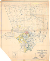
- Map of the County of Los Angeles showing Assembly and Congressional districts as established by sections 90 and 110 of the Political code
- Creator
- Jones, Alfred
- Date Created
- 1945
- Date
- 1945
- Place of Origin
- Los Angeles, Calif.
- Publisher
- Dept. of County Surveyor
- Language
- English
- Collection
- Henry J. Bruman Map Collection
Notes
- Description
-
Includes inset of Santa Catalina Island and San Clemente Island.
Blue line print.
Relief shown by hachures.
"Prepared for the Board of Supervisors, ex-officio, Election Commissioners of Los Angeles County, and for the Registrar of Voters."
Physical Description
- Extent
- 1 map
- Dimensions
- 121 x 99 cm
Find This Item
- Repository
- University of California, Los Angeles. Library. Henry J. Bruman Map Collection
- ARK
- ark:/21198/z11318wk
- Opac url
- https://search.library.ucla.edu/permalink/01UCS_LAL/trta7g/alma9922436613606533
- Manifest url
-

Access Condition
- Rights statement
- unknown