Map of the city of Los Angeles, 1897 : accompanying Maxwell's Los Angeles city directory and gazetteer of Southern California
Item Overview
- Title
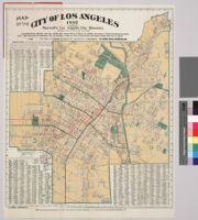
- Map of the city of Los Angeles, 1897 : accompanying Maxwell's Los Angeles city directory and gazetteer of Southern California
- Date Created
- circa 1897
- Place of Origin
- Los Angeles, Calif.
- Publisher
- Los Angeles Directory Company
- Language
- English
- Collection
- Maps of Los Angeles, California, the United States and the World, circa 1516-1970
Notes
- Description
-
Digitization took place as part of the California Cultures Project.
Rail lines over printed in red. Includes street index.
"Compiled from official surveys under the supervision of Dana H. Burks, Secretary, "Street Naming Commission" and showing all changes--326 in number--made by the Commission and approved by the City Council." "Entered according to act of Congress in the office of the Librarian of Congress at Washington, D.C. in the year 1897, by Los Angeles Directory Co."
Cover title: "Los Angeles Directory Co.'s official map of the city of Los Angeles, Cal."
Scale not given.
Physical Description
- Extent
- 1 map : col.
- Dimensions
- 62 x 51 cm. on sheet 67.5 x 54 cm. folded to 18 x 10 cm. in red printed wrappers
Keywords
- Genre
-
maps
cartographic - Location
- Los Angeles (Calif.)--Maps
- Resource type
- still image
- Subjects
- Streets--California--Los Angeles--Maps
Find This Item
- Repository
- University of California, Los Angeles. Library. Department of Special Collections
- ARK
- ark:/21198/zz00096dh9
- Manifest url
-

Access Condition
- Rights statement
- public domain