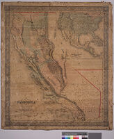
New map of California by Charles Drayton Gibbes from his own and other recent surveys and explorations
Item Overview
- Title
- New map of California by Charles Drayton Gibbes from his own and other recent surveys and explorations
- Alternative title
- Map of the United States of America, Mexico, Central America, Cuba &c
- Cartographer
- Gibbes, Charles Drayton
- Date Created
- 1852
- Place of Origin
- New York, N.Y. and Stockton, Calif.
- Publisher
- Sherman & Smith
- Language
- English
- Collection
- Maps of Los Angeles, California, the United States and the World, circa 1516-1970
Notes
- Description
-
Digitization took place as part of the California Cultures Project.
scale: 1 : 11,900
44 longitude west from Washington longitude west 119 degrees from Greenwich.
"Entered according to act of Congress in the year 1852 by Sherman & Smith in the clerk's office of the District Court of the southern district of New York"
Map indicates Utah and New Mexcio directly to the east of California. Includes inset of "Map of the United States of America, Mexico, Central America, Cuba & c.
Physical Description
- Extent
- 1 map : col.
- Dimensions
- 86.5 x 75 cm. on sheet 100.5 x 88 cm.
Keywords
- Genre
-
maps
cartographic - Location
-
Cuba--Maps
Mexico--Maps
United States--Maps
California--Maps
Central America--Maps - Resource type
- still image
- Subjects
- California -- Maps
Find This Item
- Repository
- University of California, Los Angeles. Library. Department of Special Collections
- ARK
- ark:/21198/zz0015z6x6
- Manifest url
-

Access Condition
- Rights statement
- public domain