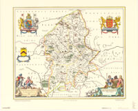
Staffordiensis comitatvs; vulgo Stafford Shire
Item Overview
- Title
- Staffordiensis comitatvs; vulgo Stafford Shire
- Uniform title
- Stafford Shire
- Creator
-
John Bartholomew and Son.
Royal Geographical Society (Great Britain).
Blaeu, Joan. 1596-1673. - Date Created
-
[1972?]
1648 - Date
- 1972
- Place of Origin
-
[Amstelodami?]
Edinburgh
ne - Publisher
- John Bartholomew & Son
- Language
-
English
Latin - Collection
- Henry J. Bruman Map Collection
Notes
- Description
-
"Johan Blaeu: Atlas novus, 1648."
Includes coats-of-arms.
Facsimile.
Scale ca. 1:200,000.
Relief represented pictorially.
"With acknowledgement to the Trustees of the National Library of Scotland."
"Published jointly with the Royal Geographical Society, London."
Physical Description
- Extent
- col. map 41 x 50 cm.
Keywords
- Genre
- map
- Subject Geographic
- Staffordshire (England)--Maps--Early works to 1800--Facsimiles
- Location
- Staffordshire (England)
- Resource type
- cartographic
- Subjects
- Staffordshire (England)--Maps--Early works to 1800--Facsimiles
Find This Item
- Repository
- University of California, Los Angeles. Library. Henry J. Bruman Map Collection
- ARK
- ark:/21198/zz002cf7b1
- Opac url
- https://search.library.ucla.edu/permalink/01UCS_LAL/17p22dp/alma9941357753606533
- Manifest url
-

Access Condition
- Rights statement
- unknown